Indonesia 印度尼西亚 => A Country of Beautiful Wood

Indonesia 印度尼西亚 => A Country of Beautiful Wood

The Artisans

Indonesian Furniture Selection

The Objects

History of Indonesian Furniture

Indonesia 印度尼西亚 => A Country of Beautiful Wood

Updated 2023-11-09 09:24:11

Indonesia is a country on the continent Asia, her capital is Jakarta. Here is the hierarchy of the Indonesia administrative divisions: Indonesia is subdivided into provinces, that are at their turn subdivided into regencies (kabupaten), cities (kota), that are at their turn subdivided into districts, that are at their turn subdivided into towns and villages.

The names of countries/territories of the world are taught in English and Chinese. This collection of precious dry lands that shares the whole mankind includes not only the world's independent countries, but also specific areas that are not a UNUnited Nations: We the peoples...A stronger UN for a better world. member. Please visit the table of male and female genders of country names in French.

Countries/locations    Close
Indonesia | Countries/Territories | Regions of China | Provinces of China | Regions in France | French Departments | States/Provinces | Cities/Towns | Locations | World Continents | French AOP Wines

161

id
Country
Country
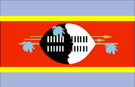
Swaziland
Country in French
Swaziland
countryucasefr
SWAZILAND
Country in Chinese
Country in Spanish
Swazilandia
Country in Italian
Lo Swaziland
Country in Portuguese
Suazilândia
Country in Germain
Swasiland
countrypy
shi3 wa3 ji4 lan2
countrylocal
Swaziland
countryfull
Swaziland
countrynm
Swaziland
ISO2
SZ
ISO3
SWZ
countrycodeisono
748
countrycodevehicle
SD
countrycodeolympic
SWZ
countrycodeirs
WZ
countrycodeirsfr
WZ
countrycodeirsmixt
WZ
♂Male
1
3
189
languagesfr
Siswati, Anglais
157
currency
lilangeni, pl., emalangeni
currencyfr
lilangeni
currencyisocode
SZL
currencyisocodefull
SZL 748
currencypxcode
SZL
currencysymbol
L, pl., E
currencysubdivision
100 cents
currencyregime
South African rand (1.0)
currencyvalue
0.1452
Capital
Mbabana
capitalfr
Mbabane
Phone Prefix
268
Area km2
17 363
arealand
17 203
areawater
160
landarablerate
0.0977
landforestrate
0.303
summit
Emlemle 1 862 m.
boundarycountries
Afrique du Sud, Mozambique.
timezonedeltabegin
2
flaglink
maplink
szcolor.gif
outlinemaplink
szout.gif
visapassenger
-1
maincities
Manzini, Big Bend, Mhlume, Nhlangano, Pigg's Peak, Stegi.
largestcity
Mbabane
largestcitypopulation
61 000
rankpopulation
151
Population
1 106 000
rankgdp
145
gdp
1845000000
rankgdpppp
139
gdpppp
5225000000
rankgni
160
gni
1496000000
rankincomeorigin
127
rankincome
139
income
1350
rankincomeppp
123
incomeppp
4850
lifeexpectation
37.54
alphabetizationrate
0.81
natalityrate
0.02855
mortalityrate
0.02306
mortalityrateinfantile
0.06835
hdi
0.547
urbanization
0.267
nationalevent
Independence Day
nationaleventfr
Jour de l'Indépendance
nationalholiday
6 September (1968)
Birthday yyyy-mm-dd
1968-09-06 00:00:00
5
9
location
Southern Africa, between Mozambique and South Africa
terrain
mostly mountains and hills; some moderately sloping plains
naturalresources
asbestos, coal, clay, cassiterite, hydropower, for
9
Web
rgbback
16777215
todate
1

162

id
Country
Country
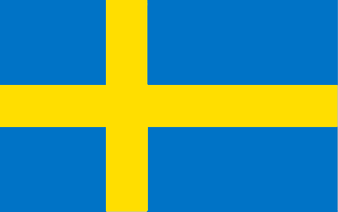
Sweden
Country in French
Suède
countryucasefr
SUEDE
Country in Chinese
Country in Spanish
Suecia
Country in Italian
La Svezia
Country in Portuguese
Sweden
Country in Germain
Schweden
countrypy
rui4 dian3
countrylocal
Sverige
countryfull
Sweden
countrynm
Sweden
ISO2
SE
ISO3
SWE
countrycodeisono
752
countrycodevehicle
S
countrycodeolympic
SWE
countrycodeirs
SW
countrycodeirsfr
SW
countrycodeirsmixt
SW
countrycode
46
♀Female
1
12
6
152
languagesfr
Suédois
98
currency
krona (pl. kronor)
currencyfr
couronne suédoise
currencyisocode
SEK
currencyisocodefull
SEK 752
currencypxcode
SEK
currencysymbol
kr or Sk
currencysubdivision
100 ören
currencyregime
m.float
currencyvalue
0.1334
nationalityfr
Suédoise
Capital
Stockholm
capitalfr
Stockholm
Phone Prefix
46
Area km2
449 964
arealand
410 934
areawater
39 030
landarablerate
0.068
landforestrate
0.659
coastline
3218
summit
Kebnekaise 2 117 m.
boundarycountries
Norvège, Finlande.
timezonedeltabegin
1
flaglink
maplink
secolor.gif
outlinemaplink
se.gif
visapassenger
-1
maincities
Göteborg, Malmö, Uppsala, Orebro, Norrköping, Västerås, Linköping, Jönköping, Helsingborg, Borås.
largestcity
Stockholm
largestcitypopulation
1 545 000
rankpopulation
80
Population
8 956 000
rankgdp
19
gdp
301606000000
rankgdpppp
33
gdpppp
239576000000
rankgni
19
gni
258882000000
rankincomeorigin
11
rankincome
8
income
28910
rankincomeppp
26
incomeppp
26710
lifeexpectation
79.97
alphabetizationrate
0.99
natalityrate
0.00971
mortalityrate
0.01058
mortalityrateinfantile
0.00342
precipitation
539
nationalevent
Flag Day
nationaleventfr
Jour du Drapeau
nationalholiday
6 June
Birthday yyyy-mm-dd
2000-06-06 00:00:00
7
5
location
Northern Europe, bordering the Baltic Sea, Gulf of Bothnia, Kattegat, and Skagerrak, between Finland and Norway
terrain
mostly flat or gently rolling lowlands; mountains in west
naturalresources
zinc, iron ore, lead, copper, silver, timber, uran
cooking
Fruits de Mer
7
Web
rgbback
16777215
todate
1
Notes
Fruits de Mer

163

id
Country
Country
Switzerland
Country in French
Suisse
countryucasefr
SUISSE
Country in Chinese
Country in Spanish
Suiza
Country in Italian
La Svizzera
Country in Portuguese
Switzerland
Country in Germain
Die Schweiz
countrypy
rui4 shi4
countrylocal
Schweiz (German), Suisse (French), Svizzera (Italian)
countryfull
Switzerland
countrynm
Switzerland
ISO2
CH
ISO3
CHE
countrycodeisono
756
countrycodevehicle
CH
countrycodeolympic
SUI
countrycodeirs
SZ
countrycodeirsfr
CH
countrycodeirsmixt
CH
countrycode
41
♀Female
8
57
languagesfr
Allemand, Français, Italien, Romanche.
99
currency
franc
currencyfr
franc suisse
currencyisocode
CHF
currencyisocodefull
CHF 756
currencypxcode
CHF
currencysymbol
SwF
currencysubdivision
100 rappen/centimes
currencyregime
float
currencyvalue
0.7966
nationalityfr
Suisse
Capital
Bern
capitalfr
Berne
Phone Prefix
41
Area km2
41 290
arealand
39 770
areawater
1 520
landarablerate
0.1057
landforestrate
0.303
summit
Pointe Dufour 4 634 m.
boundarycountries
France, Allemagne, Autriche, Liechtenstein, Italie.
timezonedeltabegin
1
flaglink
maplink
sz-map.gif
outlinemaplink
ch.gif
visapassenger
-1
maincities
Zürich, Bâle, Genève, Lausanne, Winterthur, Lucerne, Saint Gall, Bienne, Thoune, Neuchâtel.
largestcity
Bern
rankpopulation
91
Population
7 350 000
rankgdp
17
gdp
320118000000
rankgdpppp
35
gdpppp
224557000000
rankgni
17
gni
298975000000
rankincomeorigin
4
rankincome
3
income
40680
rankincomeppp
7
incomeppp
32220
lifeexpectation
80.31
alphabetizationrate
1
natalityrate
0.00983
mortalityrate
0.00844
mortalityrateinfantile
0.00443
hdi
0.932
nationalevent
Founding of the Swiss Confederation
nationaleventfr
Fondation de la Confédération Helvétique
nationalholiday
1 August (1291)
Birthday yyyy-mm-dd
1753-01-01 00:00:00
9
9
location
Central Europe, east of France, north of Italy
terrain
mostly mountains (Alps in south, Jura in northwest) with a central plateau of rolling hills, plains, and large lakes
naturalresources
hydropower potential, timber, salt
cooking
Chocolat.
5
Web
rgbback
16777215
todate
1
Notes
Chocolat.

164

id
Country
Country
Syria
Country in French
Syrie
countryucasefr
SYRIE
Country in Chinese
Country in Spanish
Siria
Country in Italian
La Siria
Country in Portuguese
Syria
Country in Germain
Syrien
countrypy
xu4 li4 ya4
countrylocal
Suriyah
countryfull
Syria
countrynm
Syria
ISO2
SY
ISO3
SYR
countrycodeisono
760
countrycodevehicle
SYR
countrycodeolympic
SYR
countrycodeirs
SY
countrycodeirsfr
SY
countrycodeirsmixt
SY
♀Female
15
1
3
languagesfr
Arabe
101
currency
pound
currencyfr
livre syrienne
currencyisocode
SYP
currencyisocodefull
SYP 760
currencypxcode
SYP
currencysymbol
£S
currencysubdivision
100 piasters
currencyregime
US-$ (11.225)
currencyvalue
0.01926
nationalityfr
Syrienne
Capital
Damascus
capitalfr
Damas
Phone Prefix
963
Area km2
185 180
arealand
184 050
areawater
1 130
landarablerate
0.2596
landforestrate
0.025
coastline
193
summit
Jabal ash-Shaykh 2 814 m.
boundarycountries
Israël, Liban, Turquie, Irak, Jordanie.
timezonedeltabegin
2
flaglink
maplink
sycolor.gif
outlinemaplink
syout.gif
visapassenger
-1
maincities
Alep, Homs, Lattaquié, Hama, Deir es Zor, Raqqa, El Haseke, Tartoûs, Idlib, Deraa, Abu Kemal.
largestcity
Damascus
largestcitypopulation
2 036 000
rankpopulation
53
Population
17 384 000
rankgdp
67
gdp
21499000000
rankgdpppp
62
gdpppp
62165000000
rankgni
71
gni
20209000000
rankincomeorigin
130
rankincome
142
income
1160
rankincomeppp
138
incomeppp
3430
lifeexpectation
69.39
alphabetizationrate
0.645
natalityrate
0.02954
mortalityrate
0.00504
mortalityrateinfantile
0.03167
precipitation
143
nationalevent
Independence Day
nationaleventfr
Jour de l'Indépendance
nationalholiday
17 April (1946)
Birthday yyyy-mm-dd
1946-04-17 00:00:00
3
11
location
Middle East, bordering the Mediterranean Sea, between Lebanon and Turkey
terrain
primarily semiarid and desert plateau; narrow coastal plain; mountains in west
naturalresources
petroleum, phosphates, chrome and manganese ores,
9
rgbback
16777215
todate
1

165

id
Country
Country
Tajikistan
Country in French
Tadjikistan
countryucasefr
TADJIKISTAN
Country in Chinese
Country in Spanish
Tajikistan
Country in Italian
Tajikistan
Country in Portuguese
Tajikistan
Country in Germain
Tajikistan
countrypy
ta3 ji2 ke4 si1 tan3
countrylocal
Jumhurii Tojikiston
countryfull
Tajikistan
countrynm
Tajikistan
ISO2
TJ
ISO3
TJK
countrycodeisono
762
countrycodevehicle
TJ
countrycodeolympic
TJK
countrycodeirs
TI
countrycodeirsfr
TI
countrycodeirsmixt
TI
♂Male
15
4
199
languagesfr
Tadjik
158
currency
somoni
currencyfr
rouble
currencyisocode
TJS
currencyisocodefull
TJS 762
currencypxcode
TJS
currencysymbol
100 dirams
nationalityfr
Tajik
Capital
Dushanbe
capitalfr
Douchanbe
Phone Prefix
992
Area km2
143 100
arealand
142 700
areawater
400
landarablerate
0.0541
landforestrate
0.028
summit
Qullai Kommunizm 7 495 m.
boundarycountries
Ouzbekistan, Kirghizstan, Chine, Afghanistan.
timezonedeltabegin
5
flaglink
maplink
tjcolor.gif
outlinemaplink
tjout.gif
visapassenger
-1
maincities
Khodzent, Kulyab, Kurgan-Tyube, Kanibadam, Tursunzade, Khorogl.
largestcity
Dushanbe
largestcitypopulation
664 000
rankpopulation
98
Population
6 305 000
rankgdp
149
gdp
1553000000
rankgdpppp
135
gdpppp
6976000000
rankgni
162
gni
1343000000
rankincomeorigin
195
rankincome
209
income
210
rankincomeppp
188
incomeppp
1040
lifeexpectation
64.47
alphabetizationrate
0.994
natalityrate
0.03263
mortalityrate
0.00842
mortalityrateinfantile
0.1121
hdi
0.677
urbanization
0.277
precipitation
569
nationalevent
Independence Day (or National Day)
nationaleventfr
Jour de l'Indépendance (ou Jour National)
nationalholiday
9 September (1991)
Birthday yyyy-mm-dd
1991-09-09 00:00:00
8
8
location
Central Asia, west of China
terrain
Pamir and Alay Mountains dominate landscape; western Fergana Valley in north, Kofarnihon and Vakhsh Valleys in southwest
naturalresources
hydropower, some petroleum, uranium, mercury, brow
9
Web
rgbback
16777215
todate
1

More+
A | B | C | D | E | F | G | H | I | J | K | L | M | N | O | P | Q | R | S | T | U | V | W | X | Y | Z
 
All<=>Deco::!Filtered Products List!

Give us feedback (44)

44. Visitor *.*.48.* - 2025-03-04 12:05:29
We are dedicated to the meticulous maintenance and repair of your truck’s braking system.
40. Visitor *.*.35.* - 2024-12-30 20:50:31
fwaga
Email Web

Please copy the string:
String to copy.

Asia Home™ > Indonesia > Swaziland 史瓦济兰 => Indonesia 印度尼西亚 => A Country of Beautiful Wood | General Sales Conditions | Returns and refunding | Privacy Policy | FAQ
  

Want to come? | Call us 7/700 33 467 790 487 (Phone)

Popup Window    Close
Patience please...